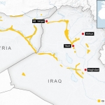
Islamic State strongholds 13.aug.2014 [940×560]
From everything I’ve understood about the situation, this is a much better visualization to understand how much land is being held. Saying they are in charge of the large swaths of land is not accurate, but clarifying that they control these stretches of land to operate as permiters is much more sensible way to understand how they’re taking as much control as they are at the moment.