What would happen if the earth stopped spinning? ArcGIS was used to perform complex raster analysis and volumetric computations and generate maps that visualize these results.
Witold Fraczek
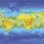
What would happen if the earth stopped spinning? ArcGIS was used to perform complex raster analysis and volumetric computations and generate maps that visualize these results.
Witold Fraczek